
The Bovec area and its surroundings are a true paradise for waterfall lovers. While the region around Log pod Mangartom and the walls of Loška Koritnica hides many spectacular cascades, waterfalls can be found throughout the wider Bovec region, from alpine valleys to forested streams.
In this guide, we’ll explore a wide range of waterfalls — from Slovenia’s mightiest, the Boka Waterfall (144 m), to the charming small cascades at Šunikov Vodni Gaj, where water tumbles just a few meters. Along the way, you’ll discover hidden gems tucked into gorges, forest paths, and alpine valleys, perfect for photographers, hikers, and anyone who loves wild nature.

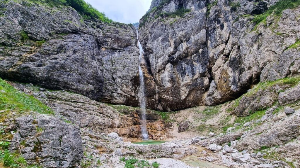
Predel Waterfalls
- Starting point: Predel Viaduct
- Coordinates: 46.4230, 13.5930
- Hiking time: ~10–20 min total
- Difficulty: Easy / family‑friendly
A short forest trail from the Predel Viaduct leads to a series of small cascades on the Predelnica stream and a larger ~50 m waterfall further upstream. Great for a quick stop or a refreshing dip after rain.

Zaročenca Waterfall
- Starting point: Parking lot a few hundred meters below the Predel viaduct
- Coordinates: 46.4201, 13.6028
- Hiking time: 20 min hike
- Difficulty: Easy
Easy walk from the roadside parking, leading to a peaceful forest waterfall along the Predelnica. A nice stop on the way from Predel to Log pod Mangartom.

Poševni Slap (The Slanted Waterfall)
- Starting point: Log pod Mangartom
- Coordinates: 46.4072, 13.6043
- Hiking time: ~45–60 min one way
- Difficulty: Moderate / some scrambling
Hidden deeper in Predelnica gorge, you’ll navigate narrow rocky sections to reach this unique diagonal waterfall and its emerald pool.

Waterfall in the Loška Koritnica Valley
- Starting point: Loška Koritnica
- Coordinates: 46.4146, 13.6295
- Hiking time: ~2.5 h (to waterfall)
- Difficulty: Moderate
A scenic alpine valley hike that reveals beautiful cascades descending from Mangart’s slopes.

Fratarica Waterfalls
- Starting point: Log pod Mangartom
- Coordinates: 46.4072, 13.6043
- Hiking time: Variable (up to 3 h+)
- Difficulty: Easy to Challenging (depending how deep you go)
A dramatic gorge with dozens of waterfalls. The standout is the Parabola (48 m), but side streams hide many other gems.

Kaludrica Waterfalls
- Starting point: Log pod Mangartom
- Coordinates: 46.4072, 13.6043
- Hiking time: ~1–2 h loop
- Difficulty: Easy / light off‑trail
Several smaller cascades formed by this quiet forest stream; exploreable with a bit of adventurous spirit.

Gorejca Waterfalls
- Starting point: Log pod Mangartom
- Coordinates: 46.4047, 13.5967
- Hiking time: 10–15 min to lower waterfall
- Difficulty: Easy; upper waterfall requires off‑trail climb
Start near Štoln and enjoy the lower 6 m cascade + shady pools, then continue up to a higher ~40 m tier if you’re up for it.

Prešnik Gorge Waterfalls (incl. Sun Path waterfall)
- Starting point: Parking lot at the entrance to the Možnica Valley
- Coordinates: 46.3904, 13.5876
- Hiking time: ~1 h
- Difficulty: Moderate
A narrow rocky gorge with a cluster of cascades; the prettiest is the ~15 m Sun Path Waterfall.

Možnica Valley Waterfalls
- Starting point: Parking lot at the entrance to the Možnica Valley
- Coordinates: 46.3904, 13.5876
- Hiking time: ~3 h round trip
- Difficulty: Easy to Moderate
The Možnica stream has carved wonderful gorges and pools; the highlight is an 18 m waterfall that plunges through a natural rock window.

Slap Virje
- Starting point: Pluže
- Coordinates: 46.3357, 13.5130
- Hiking time: ~10–15 min to main vantage
- Difficulty: Easy
- Optional: 20 min for waterfall + source + small lake loop
Just outside Bovec near Plužna, Virje Waterfall drops ~12 m into emerald pools. A short, family‑friendly trail leads to the falls. Continue a bit further to explore the Izvir Glijuna (source of the Glijun River) and a reservoir lake if you have extra time.

Slap Boka (Two Options)
Boka – Viewpoint Trail
- Starting point: Bridge over Boka river
- Coordinates: 46.3180, 13.4937
- Hiking time: 15 min to main viewpoint, for higher viewpoints it takes about 20-40 minutes more
- Difficulty: Easy to Moderate (rocky path). The higher the path, the more challenging it becomes.
From the roadside parking next to the bridge over the Boka River, take the marked trail to a panoramic viewing platform. About 15 minutes up, this offers superb views over Slovenia’s mightiest waterfall.

Boka – Hike to Source of Boka
- Starting point: Bridge over Boka river
- Coordinates: 46.3180, 13.4937
- Ascent time: ~1.5 h
- Difficulty: Very demanding (steep, rocky)
For hikers looking for more, you can climb to the source of the Boka River, which is directly above the waterfall. The trail is unmarked and very challenging in places.
Boka Waterfall itself drops a staggering 144 m in two stages and can be seen right from the nearby road, but the view from above the mighty waterfall is very special.

Waterfalls on Globoški Potok
- Starting point: Žaga
- Coordinates: 46.310, 13.481 (approx start near Žaga)
- Hiking time: 45–60 min to main cascade
- Difficulty: Easy to Moderate
Globoški Potok flows down dramatic red rock channels and forms several cascades, the most notable being the multi‑tiered Sapet waterfall and its deep swimming pool.

Šunikov Vodni Gaj & Šumnik Waterfalls (Lepena)
Šunikov Vodni Gaj
- Starting point: Lepena Valley
- Coordinates: 46.3126, 13.6579
- Hiking time: ~30 min loop
- Difficulty: Easy
A picturesque water garden by Lepenica River with small cascades, pools, and forest paths — perfect for a relaxed afternoon.

Šumnik Waterfalls
- Starting point: Lepena Valley
- Coordinates: 46.3126, 13.6579
- Hiking time: ~1 h 15 min
- Difficulty: Easy to Moderate
A lesser-known but beautiful stream that flows into the Lepenica at the end of Šunik water gaj.
The stream is reached by a rather overgrown path, but the higher waterfalls, pools and cascades are easiest to see if you follow the Path of Peace, which leads only about 10 m from the stream.
The tour is suitable for those who are looking for something more, who are more experienced adventurers

If you are looking for ideas for similar trips around Slovenia, I suggest the links below:
- Trenta valley, things you do not want to miss
- What to see and do in Bohinj
- Kobarid attractions
- Tolmin – Top Things to Do
- Best things to do in Kranjska gora
- What to see and do in Idrija
- Koper: Slovenia’s Coastal Gem
- Logar valley: Nature’s Alpine Paradise
🌟 Tips for Visiting Waterfalls Around Bovec
- ✔️ Many waterfalls are seasonal — visit in spring or after rain for best flow.
- ✔️ Combine shorter, easier waterfalls (Predel, Virje, Prešnik) with longer hikes (Možnica, Boka higher viewpoints) for a varied experience.
- ✔️ Always wear good hiking shoes — terrain can be demanding, rocky and slippery.

